
Lat Long Calc
Descrizione di Lat Long Calc
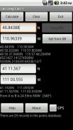
Lat Long Calc is a GPS tool that converts latitude/longitude coordinates to different formats and calculates distance and direction between two points. This is the free version. For more features look for Lat Long Calc Pro.
** If you find a bug, e-mail me and I will fix it. **
Of particular use in Search and Rescue (SAR) & GIS where conversion between different formats is needed.
Also useful in Geocaching, surveying or anything where you need to convert coordinates between formats.
Please contact me at cruthuservices@gmail.com for help before rating poorly.
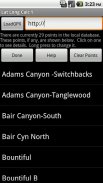
Supports DD.DDD, DD MM.MMM, DD MM SS.SSS, UTM and Maidenhead Locator. Can load points from a GPX and/or save points in local DB for later use.
Maidenhead Locator (4 or 6 digit) is useful for Ham (Amateur) Radio contacts or contesting.
Can use internal GPS to get current position which can also be saved to a local DB.
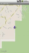
Includes mapping support. See your positions on a map. Options to use internal rendered Google Maps or external map provider such as Google Maps, or other map programs.
Long click on coordinate results to show map. Read help for more details.
Does not share any information. Internet access is for downloading your specified GPX file. GPS is only used if you select it.
Now has batter support for small screen devices.
Note: Mapping support requires Google Maps be installed.
Lat Long Calc è uno strumento GPS che converte latitudine / longitudine coordinate in diversi formati e calcola la distanza e la direzione tra due punti. Questa è la versione gratuita. Per ulteriori funzioni cercare Lat Long Calc Pro.
** Se si trova un bug, e-mail me e io lo risolverà. **
Di particolare l'uso in ricerca e salvataggio (SAR) e GIS in cui è necessaria la conversione tra diversi formati.
Utile anche in Geocaching, la topografia o qualsiasi cosa in cui è necessario per convertire le coordinate tra i formati.
Si prega di contattarmi al cruthuservices@gmail.com aiuto prima a rating male.
Supporta GG.mmm, DD mm.mmm, GG MM SS.SSS, UTM e Maidenhead Locator. Può caricare punti da un GPX e / o salvare punti nel DB locale per un uso successivo.
Maidenhead Locator (4 o 6 cifre) è utile per Ham contatti (Dilettante) RADIO o contestare.
Può utilizzare il GPS interno per ottenere la posizione corrente che può anche essere salvato in un database locale.
Include il supporto mappatura. Vedere le vostre posizioni su una mappa. Opzioni per uso interno resi Google Maps o fornitore di mappe esterno, come Google Maps o altri programmi della mappa.
Long click sulla coordinata risultati per mostrare la mappa. Per saperne di aiuto per maggiori dettagli.
Non condividere alcuna informazione. accesso a Internet è per scaricare il file GPX specificato. GPS viene utilizzato solo se lo si seleziona.
Ora ha il supporto per i dispositivi pastella piccolo schermo.
Nota: Il supporto di mappatura richiede essere installato Google Maps.
Lat Long Calc - Versione 2.0.0
(21-06-2018)Lat Long Calc - Informazioni APK
Versione APK: 2.0.0Pacchetto: com.cruthu.latlongcalc1Ultima versione di Lat Long Calc
Altre versioni


App nella stessa categoria


Potrebbe piacerti anche...